
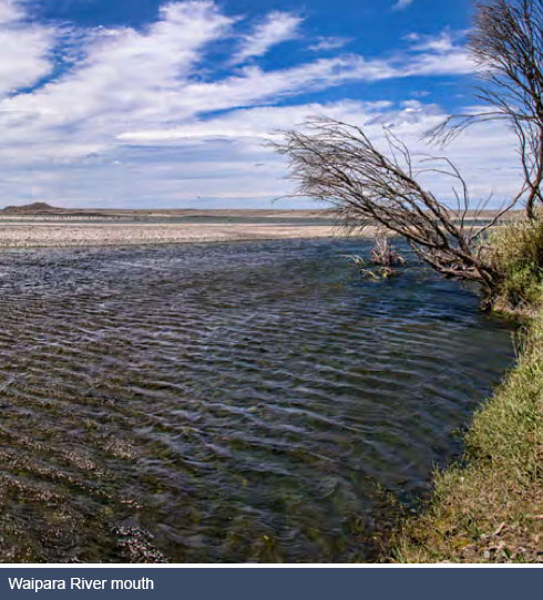
Waipara River Mouth
The Waipara River Mouth Management Area covers that portion of the Waipara River located between the coast and Webbs Road. The river flows across a narrow coastal plain to the Waipara Lagoon at the coast. The lagoon consists of still water with unstable gravels and bars between it and the sea. The lagoon is narrow and extends largely to the north of the river, immediately behind the beach. The lagoon is generally opened to the sea by freshes of 8-10 cumecs in the Waipara River and closes again when flow falls below 4 cumecs. The District Plan identifies the river mouth and lagoon to the north as a Significant Natural Area (SNA6) and is described as ‘an unstable mouth of small braided river with flow fluctuations causing frequent changes’. The nature of the river mouth reflects the balance between coastal and fluvial processes, principally during extreme conditions. The form of the mouth is influenced predominantly by extreme events. There is minor use of the river mouth and lagoon for whitebaiting when flows are suitable and the area is also popular for game-bird hunting during the season.
The Waipara River mouth is an important and regionally unique estuarine system having moderate to high values for wildlife. The river mouth is ranked as having national to international significance for threatened bird species. Threatened species found in this area include the wrybill, bittern, black fronted tern and banded dotterel. A total of 25 wetland bird species have been recorded, including migratory waders which are otherwise uncommon in New Zealand or Canterbury. Wader numbers are variable and when river flow is low suitable habitat is limited. This area is also an important nesting and feeding ground for a number of bird species. The community is concerned that these important bird nesting sites are protected from vehicle damage and pest animals.
The lagoon and associated coastline was a significant source of mahinga kai for Ngāi Tahu and under the Ngāi Tahu Claims Settlement Act 1998 a nohoanga site was established towards the end of Golf Links Road. It is not clear exactly where the site is located. It is important to know the exact boundaries of the site to ensure that it is located outside of the proposed vehicle prohibition area. While Ngāi Tahu has exclusive camping rights at this site for up to 210 days per year, the reality is that the nohoanga is not actively used by Ngāi Tūahuriri as the coastal lagoon to which it relates no longer holds the kai that it once did.
The Waipara River mouth area contains a number of archaeological sites as identified in the District Plan. The River mouth was the site of a prolonged and sustained occupation with two pa sites located on the northern side of the river. The importance of the Waipara River and lagoon are reflected in the Statutory Acknowledgement under the Ngai Tahu Treaty Claims Settlement Act 1998. One of the main priorities for Te Ngai Tuahuriri is better access to and management of the lagoon for mahinga kai.
The surrounding landscape is predominantly unmanaged shrubland, in which exotic trees such as willows, shrubs and grasses are predominant. The community is keen to enhance the natural environment in this area through some of revegetation project.
There are two public access points to the Waipara River in this area. These are located at the end of Webbs Road and Golf Links Road. There is a defined 4WD vehicle track along the north bank of the river to the topographical feature locally referred to as The Rocks – a rocky headland located at the northern most part of Pegasus Bay approximately 2.5 km north of the river mouth. The Rocks is a popular picnic, camping and fishing spot with small boats launched directly from the beach. The 4WD vehicle track currently crosses private land and as such it is important that this route either be legitimised or re-routed so that it traverses publicly owned land.
- Action map
- Waipara River mouth - permissions and restrictions
- Webbs Road - permissions and restrictions
- River mouth ecology
- Significance to Maori
Northern Pegasus Bay Bylaw 2010
In terms of vehicle access in the estuarine area at the river mouth, the Northern Pegasus Bay Bylaw 2010 seeks to control activities and the use of land, including the use of vehicles, on the foreshore, beaches and adjacent areas of Northern Pegasus Bay. Clause 10.1 of the bylaw specifies that ‘no person shall drive any vehicle or ride, lead or otherwise use any horse or horses within the prohibited vehicle area marked on Map H2’. The vehicle prohibited area identified in Map H2 of the bylaw has been reproduced on the Action Map for the Waipara River Mouth Management Area to identify that area where vehicles are prohibited. However, clause 10.2 of the bylaw specifies that ‘Notwithstanding clause 10.1 and Map H2, a person may drive a vehicle within the prohibited vehicle area marked on Map H2 during the whitebaiting season, for the purpose of whitebaiting, provided they remain on an access track marked by the Council.’